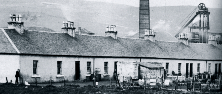
Lugar lies two miles east of Cumnock beside the Lugar Water. Founded in 1845 by William Baird and Company Lugar’s row’s housed ironworkers for the Lugar ironworks as well as colliers and ironstone miners for the surrounding pits; coal and iron mined from these pits would be used by the Ironworks until the end of the nineteenth century.[1] When Lugar was built it had 177 homes situated in 6 separate rows, although Belloholm Row itself was separated into two blocks of rows.[2] Indoor water and toilet amenities was not present in the miners rows until the construction of park Terrace in 1925.[3]
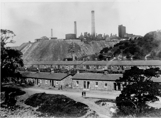
IMAGE: Lugar village in about 1900, with the modernised ironworks in the background. The rows in the foreground were built for the 1845 works, and the ones in the middle distance were constructed by the Eglinton Iron Company. Source: unknown
For services Lugar had its own train station although ‘at some distance from the village’.[4] Whilst industrial output remained high regular rail service remained but as output declined so did these services until the closure of the station to passengers in 1950, finally closing fully in 1976. Belloholm row also had a dwelling which acted as a police station until at least the 1950s when a new building was constructed.[5] There was also a schoolhouse as well as a church which dates from 1867.[6] The police officer, schoolmaster and church minister would have been considered more wealthier compared to the other residents. Originally, only one store existed which was ran as a monopoly by the company. By the 1950s this store was now ran by the Lugar Iron Works Co-operative Society whilst another was operated by the post office.[7]
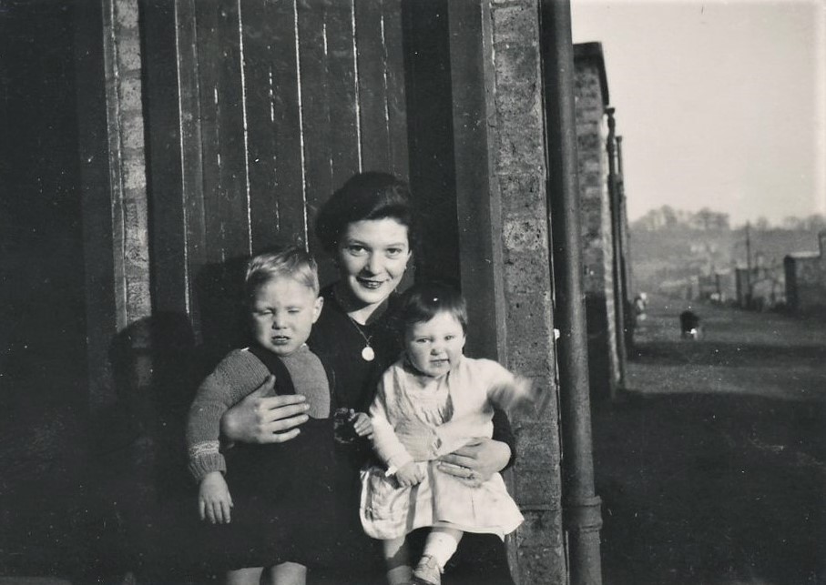
IMAGE: Helen White with Hugh White and Margaret White, outside 472 Brick Row, Lugar, c,1944. Reproduced with permission from Kevin White.
The principle recreation building was the Weir Institute gifted by company shareholder William Weier of Adamton in 1892. Following the companies pro-temperance beliefs no public house was constructed. The Institute held a reading room as well as a heated swimming pool, which was later converted into a dance hall and as storage for the Lugar Brass Band.[8] The institute would close in 1965, with commercial ventures briefly owning the building until becoming the ruinous state which it exists today. For sports a badminton club was founded as well as a bowling green in 1925,[9] but, football has a longer history with Lugar Boswell Thistle FC existing since 1878 and ‘was considered a local force in senior circles’ during the late nineteenth century.[10] Based on Rosebank Park, the ground was built on the site of the old Rosebank Mine. The club still exists as a junior club.
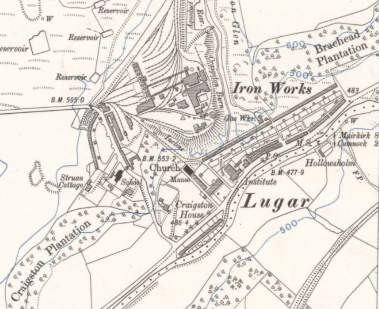
Lugar at its peak. OS Surveyed / Revised:Pre-1930 to 1957, Sheet NS41SW – A, Published: 1958. Permission of the NLS https://maps.nls.uk/index.html
Lugar’s industry expanded to include a brick works and gas works. As industry expanded so did Lugar’s population. Lugar’s population would reach its highest by 1910 with 1,850 people living in the rows, however, the following decades would see a decline which coincided with industrial decline with Lugar ironworks being closed in 1928 and the Lugar Pit having the same fate in 1954.[11] By the beginning of the 1950s Lugar’s population was now just over a thousand and the rows were now owned by the nationalised National Coal Board since 1947.[12] The late 1950s saw the beginning of demolishing the older rows with Craightonhom Row first being demolished, with two more rows being demolished in 1961. Most of the vacant land was rebuilt with newer homes with the exception of Peesweed Brae and the Cresent which became forestry. Many of the former residents of Lugar were offered new homes in nearby Logan[13]
Contributed by Billy Cassidy, MSc Placement student from the University of Strathclyde.
Bibliography
Strawhorn, John., and William Boyd. Ayrshire. The Third Statistical Account of Scotland. V.1 (London: Oliver and Boyd, 1951)
Love, Dane. Lost Ayrshire : Ayrshire’s Lost Architectural Heritage. (Edinburgh: Birlinn, 2005)
McDowell, L. Mathew (2012), Football, Migration and Industrial Patronage in the West of Scotland, c. 1870-1900. Sport in History, 32:3, 405-425.
[1] J. Strawhorn, and W. Boyd, Ayrshire. The Third Statistical Account of Scotland. V.1 (London: Oliver and Boyd, 1951), p.91
[2] D. Love, Lost Ayrshire: Ayrshire’s Lost Architectural Heritage. (Edinburgh: Birlinn, 2005), p.120
[3] Strawhorn & Boyd, Third Statistical Account, p.665
[4] Ibid
[5] Love, Lost Ayrshire, p.120; Strawhorn & Boyd, Third Statistical Account, p.664
[6] Love, Lost Ayrshire, p.120
[7] Strawhorn & Boyd, Third Statistical Account, p.665
[8] Love, Lost Ayrshire, p.196; Strawhorn & Boyd, Third Statistical Account, p.667
[9] Strawhorn & Boyd, Third Statistical Account, p.667
[10] M. L. McDowell (2012,) Football, Migration and Industrial Patronage in the West of Scotland, c. 1870-1900. Sport in History, 32:3, 405-425
[11] Love, Lost Ayrshire, p.120
[12] Strawhorn & Boyd, Third Statistical Account, p.664
[13] Love, Lost Ayrshire, p.120